- Instructor: Joshua Mwankusye
- Students: 350
- Duration: 3 weeks
COURSE COMPETENCES
- The difference between the various data models.
- Analyze data using vector and raster methods in mult-
criterial analysis. - Understand some advanced topic in raster data analysis.
- Design and implemention of a GIS project.
COURSE CONTENTS
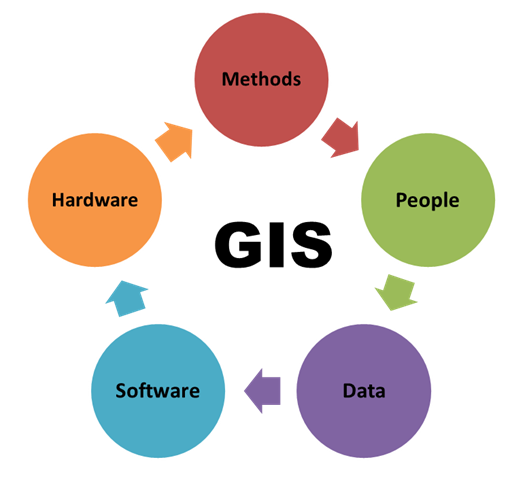
- Introduction to GIS concept.
- Map production in GIS.
- Using a GPS and integrating data into GIS.
- Spatial analysis.
- Development of GIS project.
DURATION
3 Hours Each Working Day

Requirements
- Education Level: Form Four (IV) and Above
- Working Experience: Not Required
- Age: 15 Years and Above
Features
- The purpose of this course is to promote the participants theoretical and practical knowledge of GIS.
Target audiences
- Plan officer, Environment, Data analysis, Property development, Emergency response, Transport, Military defense, Oil and gas, Agriculture, mining, disaster risk management Forestry, Engineers, Telecommunications Utilities, Geographers, Teachers and Students.
Related Courses

Life Skills
COURSE COMPETENCES Identify problems. Solve problems. Maintain good relation. COURSE CONTENT Understanding Personalities. Good interpersonal relationship and effective communication. Creative problem solving and effective decision making. Negotiation and conflict resolution. Sexual and reproductive health Gender concern. Achieving career goals and vision. Creative and critical thinking. Referrals and linkages. Customer care.…
English for Non Native Speakers
COURSE COMPETENCES Grammar partens. Conversation aspects. COURSE CONTENT Learning Language structure. Identifying sentences. Appropriate use of tenses. Expressing opinions, ideas and giving simple instructions. MODE OF EVALUATION OF PERFORMANCE The course shall be conducted through demonstration and practical Venue The course will be conducted at VETA KIPAWA ICT CENTER. In…

Event Planning
COURSE COMPETENCES Search for tenders. Plan wedding activities and budget. Analyses venues and menus. Organize music, wedding entertainment and wedding cars. Organize activities timely. COURSE CONTENTS Overview of Wedding activities and budget. Understanding Venues and Menus. Organizing Music and Wedding Cars Wedding entertainment. Photography and Video graph. Wedding Planning &…

Customer Care
COURSE COMPETENCES Identify customers and their needs. Identify standards ways of communicating with customer. Managing customers’ problems. COURSE CONTENT Concept of customer service. Knowing customer. Understanding Customer Needs and Expectation. Standards. Communication. Telephone Techniques. Managing Conflict in Customer Situations. Dealing With Challenges. Dealing with Difficult People. Seven Steps to Customer…
Business Plan
COURSE COMPETENCES Research and analyze the individual components needed for a business plan. Apply skills to create a business plan for different audiences, including investors, banks, and other stakeholders. Explain the purpose and future of their business in easy to understand terms. Use accounting terms to describe the future for…